The Arms of Australia Inn Museum: Emu Plains

The Arms of Australia Inn Museum located on the Great Western Highway, Emu Plains, NSW
The Arms of Australia Inn Museum, located on the Great Western Highway, Emu Plains, was built it two sections, the first in 1826.

The inn was once a staging post for travellers from Sydney going over the Blue Mountains to Bathurst and the goldfields.

The original building was part of Governor Macquarie’s Experimental Prison Farm, possibly the tanner's hut. The inn was probably licensed as the Mountaineer Inn in 1837 before being licensed as The Arms of Australia in 1841.

Businesses along the Great Western Road collapsed after a rail line opened to Bathurst in 1869.

The Arms of Australia was a ruin for years until it was saved from demolition and restored and officially opened on 27th March 1976 as a museum of local history.

The Inn is also the Headquarters of the NSW Corps of Marines.
Headquarters of the NSW Corps of Marines.is the Arms of Australia Museum, Emu Plains, Sydney Australia.

Some Interesting Facts

The greater Blue Mountains area has six distinct Aboriginal peoples—Darug, Gundungurra, Wiradjuri, Wanaruah, Darkinjung, and Tharawal.

In 1789, Governor Arthur Phillip was leading a boat expedition when they came upon Aboriignal people on the Branches of the Hawkesbury River northwest of Sydney, whom they called "The Branch" natives. Phillip’s party camped with Aboriignal men, Gomebeere and Yellowmundy, and David Collins recorded some Aboriginal language.

In August 1790, on an expedition led by Watkin Tench, a British Marine officer, the area was named Emu Island after he saw emus and mistakenly believed the land across the Nepean River was an island.

A government farm with convict labour was established at Emu Plains in 1813, with 1326 convicts.

William Cox was tasked by Governor Macquarie on 18 July 1814, to construct a road across the Blue Mountains to Bathurst. It was completed in 1815. (less than 6 months)
Freeman's Journal (Sydney, NSW : 1850 - 1932), Thursday 24 July 1919,
The renown naturalist, Charles Darwin, stayed at Emu Plains on his visit to Australia in 1836. Darwin stayed at the inn at "Emu Ferry", and the next morning, he crossed Nepean River in a ferry boat and ascended the Blue Mountains.
CHARLES DARWIN IN 1854. Darwin made the most of Jiis opportunity of seeing the country. He hired two horses in Sydney and obtained the services of a man to accompany him on a journey over the Blue Mountains to Bathurst. Leaving Sydney on the morn- ing of January 16, and travelling in a leisurely fashion, with a day’s halt at Wallerawang, they reached the little City of the Plains, then almost seventeen years old, on the evening of the 20th. The first night was passed “at a very comfortable inn at Emu ferry, thirty-five miles from Sydney, and near the ascent of the Blue Mountains.” You may still see the old buildings of the inn, close to the railway line upon the eastern bank of the Nepean. It was a famous hostelry all through the coaching days, and was known as "Squires’,” after the most celebrated of its licensees. Early the next morning they were ferried across the river, and commenced the ascent of the Mountains.The Lone hand. New Series Vol. 1 No. 4 (2 March 1914)
Emu Ferry Inn, NSW, The two-storey convict built Inn was one of the earliest and best known in the district. It had a carved staircase, made by convict labour. There were wide over-hanging eaves and the many windows had small panes of glass. There were sixteen rooms in the building. A huge pepper tree grew out the front with a camping ground nearby for the teamsters who made up a large proportion of the travellers in the early days.It began life in 1827 as the Emu Ferry Inn or Wilson’s Hotel. The reason being that Wilson ran the inn and the ferry at that spot. He was the step-son of Josephson who built the inn. There was no bridge across the river. It was quite profitable for Wilson to run the ferry across the river as well as run an inn because he could decide if the river was too high, low or muddy to run the ferry and in consequence he probably did a good trade.
Until the 1850s, the Nepean River was crossed at Emu Ford, often using the punt service.

Emu Ferry Post Office opened on 1 April 1863.

The Victoria Bridge was designed by Engineer in Chief of Railways John Whitton from 1862-7 as part of the Penrith to Weatherboard (Wentworth Falls) railway line.

First passenger train crosses Victoria Bridge in 1867.

By 1867, there were seven hotels at Emu Plains, according to the government gazette of that year.

The Emu Plains Railway Station opened on 18 August 1868.

The township of Emu was renamed Emu Plains in 1882.
View of Emu Plains from Lapstone deviation, NSW, Sydney Mail (NSW : 1912 - 1938), Wednesday 27 October 1926

Also in Emu Plains

Also located on Great Western Hwy, near The Arms of Australia Museum, is Mortimer's House, built in 1830. The house, was first owned by Joseph Barrow Montefiore, (after whom Montefiore's village, Wellington, is named) from 1830-1833. However, the building is named after its most famous resident, John Mortimer, who was the innkeeper of the nearby Arms of Australia Inn.

"Emu Hall", Emu Plains, was built in 1852 for race horse owner and MP James Ryan. The building was renovated in 2018, and is now a restaurant.
"Emu Hall", Emu Plains, NSW,was built in 1852 for race horse owner and MP, James Ryan. The building was renovated in 2018, and is now a restaurant
St Paul's Anglican Church was built in 1848.

O'Donaghue's Irish House was originally built by William George Clark in 1886 and called the Emu Inn (known as “The Emu”). In 1937, it reopened as the Orient Hotel. In 1937, the Orient became the Nepean. In 1998, it became an Irish pub.

Artists Gerald Lewers (1905–1962) and Margo Lewers (1908–1978) donated their house (c1900) to the local community, and it is now Penrith Regional Art Gallery.

Around Emu Plains 


On the corner of Russell Street and Great Western HWY, Emu Plains, NSW. The original Emu Plains Post Office
Arms of Australia Inn Museum: Corner of Great Western Highway and Gardenia Avenue, Emu Plains,  NSW
Plaque commemorating the Bicentenary of The Crossing of the Blue Mountains, by Blaxland, Lawson and Wentworth in May 1813
The original, Emu Plains Public School was officially opened by Sir Henry Parkes, Premier of New South Wales, in August 1877. Emu Plains, NSW
The pedestrian and cyclist bridge spanning the Nepean River between Penrith and Emu Plains, NSW
St Paul's Anglican Church was built in 1848, Emu Plains, NSW
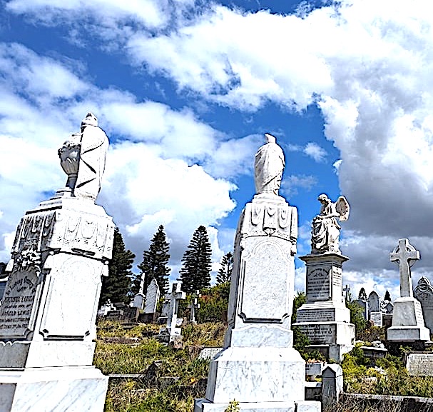
Historic cemetery, Emu Plains, NSW

Places To Go

Arms of Australia Inn Museum: Corner of Great Western Highway and Gardenia Avenue, Emu Plains, 2750. Ph: (02) 4735 4394. Open Sundays 1pm-5pm.

Penrith Regional Gallery and The Lewers Bequest, 86 River Road Emu Plains. (02) 4735 1100

Emu Plains Anglican Church, 26 Short St, Emu Plains

Emu Hall, 2-26 Great Western Hwy, Emu Plains NSW

O'donoghues Irish Pub, 99 Great Western Highway Emu Plains NSW

Waverley Cemetery: Overlooks The Pacific Ocean between Bronte and Clovelly

Cadigal people of the Eora nation lived a hunter gatherer life along the coastal areas of today's Sydney basin.

Waverley Cemetery was built on the site of a former horse tram terminus in 1875. Today, Waverly Cemetery is a picturesque and tranquil place of reflection.

The cemetery showcases outstanding Victorian and Edwardian stonemasonry, set in the beautiful location on the cliff tops overlooking the Pacific Ocean. The 41 acre site has over 50,000 graves, with many elaborate headstones and statues.

It was possible to travel to the cemetery by steam tramway in 1890, when the line between Waverley and Randwick opened.

Many famous and notable people are buried at the site. Such as: Henry Lawson (Australian poet), Jules Archibald, founder of The Bulletin and benefactor of the Archibald Prize, nineteenth century writer Louis Becke, nineteenth century Australian boxing champion Larry Foley, nineteenth century poet Henry Kendall, the American actor William E. Sheridan, poet and author Dorothea Mackellar, and author Ethel Pedley.
A State funeral was very fittingly accorded Henry Lawson, who died at Abbotsford on Saturday morning, aged 55. The body was interred in Henry Kendall'sgrave in the Waverley Cemetery.
Sydney Mail (NSW : 1912 - 1938) Wed 6 Sep 1922
FUNERAL OF THE LATE CRITCHETT WALKER, MONDAY, JUNE 15,1903 (arrival at Waverley Cemetery).Sydney Mail and New South Wales Advertiser (NSW : 1871 - 1912), Wednesday 24 June 1903
Sydney Morning Herald (NSW : 1842 - 1954), Monday 19 March 1928,
Other significant figures include aeronautical pioneer Lawrence Hargrave, Olympic swimmer Fanny Durack, and New South Wales Premier Sir James Martin.

There are over 200 war graves and monuments from various conflicts, including World War I and World War II.

Surprisingly, there are various graves belonging to United States Civil War veterans at Waverley, including Phineas S. Thompson.
Critic (Adelaide, SA : 1897-1924), Saturday 21 July 1900
Michael Dwyer, an Irish revolutionary and political exile called the "Wicklow Chieftain", is buried at Waverley. 

Dwyer was a captain in the Irish Rebellion of 1798, leading the United Irish forces in battles in Wexford and Wicklow, who was transported to New South Wales as an un-sentenced exile and free man in 1806. 

When Dwyer died in 1825, he was interred at Liverpool, then reburied in the Devonshire Street Cemetery, Sydney, in 1878. In 1898, his remains were re-interred in Waverley Cemetery.
Michael Dwyer (1772–1825) was a Society of the United Irishmen leader in the 1798 rebellion. He later fought a guerilla campaign against the British Army in the Wicklow Mountains from 1798-1803. Dwyer was celebrated for his resourcefulness and courage, although he could also be ruthless. He survived huge ransoms and the thousands of British troops sent to Ireland to kill him. Gaeilge: Náisiúnaí Éireannach ab ea Michael Dwyer (1772 - 23 Lúnasa 1825). Ball de na hÉireannaigh Aontaithe ab ea e, agus bhí sé páirteach in Éirí Amach 1798. Nuair a theip ar an Éirí Amach chúlaigh sé le buíon fear go Gleann Imeáil, agus throid siad ar feadh cúig bliana eile i Sléibhte Chill Mhantáin go dtí mí na Nollag 1803, nuair a theip ar éirí amach Robert Emmet i mBaile Átha Cliath.
Robert Rice Howard ("Nosey Bob" Howard), who was employed as a hangman for the colony of New South Wales from 1875, is buried at Waverley Cemetery. 

Nosey Bob's wife died, and he reared 5 children alone. He lost his nose when kicked in the face by a horse.
Portrait of 'Nosey Bob' Howard, New South Wales hangman; published in Truth (Sydney), 20 January 1901, page 5.

Around Waverley Cemetery

Waverley Cemetery, NSW
This memorial is the final resting place of Michael Dwyer, "The Wicklow Chief" a revolutionary leader of the 1798 Irish Rebellion who died in Sydney in 1825. Waverley Cemetery, NSW
Waverley Cemetery, NSW

Waverley Cemetery, NSW
Angel and boy Kate Fiaschi's Grave, Waverley Cemetery, NSW

Things To Do

Friends of Waverley Cemeteries, Walks

iCemetery is free to download and is available for Android and Apple devices via Google Play or iTunes

Waverley Walks

Berrima: Established in 1831

The location for Berrima Courthouse was first chosen in 1834, taking another 3 years to complete construction. Built of hand-hewn sandstone in Regency style, Berrima, NSW
Berrima is an historic town located 125 kilometres southwest of Sydney.

The area around Berrima was part of the traditional Dharawal lands, which encompass some 450 square miles (1,200 km2).

This well-preserved Australian Georgian colonial town has many charming buildings, shops and cafes to explore.

The name "Berrima" is believed to derive from an Aboriginal word meaning either "southward" or "black swan".

Harper's Mansion, overlooking the town, was built from 1829 to 1830.

New South Wales surveyor-general Thomas Mitchell chose Berrima townsite on the road from Sydney to Goulburn. It was surveyed in 1830 with the intention that it would become an administrative centre.

The courthouse was built between 1833 and 1838.

A convict stockade was established here in 1830 for road building.

The Surveyor General Inn was built in 1834.
Australia's oldest licensed inn - built 1834, Berrima, NSW (Aussie Mobs)
The gaol was built from 1835 by convict labour and opened in 1839.

There were fourteen hotels in or near the town in the 1840s.

Holy Trinity Anglican Church, designed by Edmund Blacket, was built in 1849.

St Francis Xavier Catholic Church was built 1849–51.

In 1915, Berrima Gaol was reopened as an internment camp for German prisoners. By 1917, the internees had establishment vegetable gardens outside the gaol.
In 1915, Berrima Gaol was reopened as an internment camp for German prisoners, serving as a satellite camp of the large Holsworthy Internment Camp at Liverpool, along with Trial Bay Gaol and a number of other facilities in the State. With the declaration of War in 1914, people of German origin and German property immediately became the "enemy". Berrima, NSW, Aussie~mobs
Sentry on Duty at the BerrimaConcentration Camp, NSW, Northern Herald (Cairns, Qld. : 1913 - 1939), Friday 15 December 1916
OLD DRINKING TROUGH BERRIMA, situated 84 miles from Sydney —a short distance from the main southern highway near Moss Vale —possesses in its Courthouse the oldest building in Australia, next to the Church of England at Windsor (N.S.W.). Of local stone, the Courthouse was erected in 1839, and the Berrima Gaol, opposite the Courthouse, followed some years later. The gaol was first used in 1859 and closed in 1909, but gained further history as a German Concentration Camp during the Great War. The accompanying illustration shows the drinking trough, built in the wall of the gaol. A broad arrow and the date, 1877, are cut into the stone under the ox’s head and its surround, which are of worked iron. In the early days of the settlement, much business was transacted at the Berrima Courthouse, and for the many who came on horseback or in horse-drawn vehicles, the trough provided a watering-place for the horses, as well as for passing stock, the water being pumped from a well inside the gaol grounds. Walkabout. Vol. 4 No. 10 (1 August 1938) Berrima was bypassed by a new section of the Hume Highway in March 1989. Berrima, NSW, Walkabout Vol. 4 No. 10 (1 August 1938) 

Heritage Listings

  • Argyle Street: Berrima Correctional Centre (from 1839)
  • Argyle Street: Berrima Internment Camp Huts Area (from 1915 to 1918)
  • Argyle Street: Berrima Post Office (1886)
  • Argyle Street: Holy Trinity Anglican Church (1849)
  • Hume Highway: St Francis Xavier's Roman Catholic Church (1849-51)
  • Jellore Street: Berrima Inn (by 1834)
  • Jellore Street: Victoria Inn ( first licensed in 1840)
  • 12 Jellore Street: CBC Bank Building (completed by 1836)
  • 16 Jellore Street: Jellore Cottage (1860s)
  • 19 Jellore Street: Berrima House (1835)
  • 24 Jellore Street: Mail Coach Inn (built from 1833 to 1841)
  • 5–7 Market Place: Magistrate's House (1830s to early 1840s)
  • Market Street: White Horse Inn (from 1834-1850s)
  • 5 Market Street: Nurses Cottage (1890)
  • Stockade Street: Makin Cottage
  • Wilkinson Street: Harper's Mansion (1829 to 1830)
Around Berrima

The Surveyor General Inn was built in 1834, Berrima, NSW
Berrima heritage cottage, NSW
The old Berrima Gaol was built in 1835–39 of local sandstone, NSW
Berrima, NSW
The Governor's Residence at Berrima Correctional Centre, NSW
CBC Bank Building is a heritage-listed bank building at 12 Jellore Street, Berrima, NSW
Taylor's Crown Inn, hand-built by convicts in 1844, Berrima, NSW
Commerical hotel built in 1858, Berrima, NSW. Now restaurant

Things To Do


Berrima Historic Walk

Places to Eat and Explore

Berrima Market Place Park, Old Hume Highway, Berrima NSW

The Coal Loader: Waverton Peninsula.

The Coal Loader: Waverton Peninsula, NSW
Located in Waverton on the Balls Head peninsula, a short drive from Lane Cove in North Sydney, the Coal Loader has layers of history to explore. 

The site, was occupied by the Cammeraygal people, and there is an Aboriginal rock carving of a marine creature to see. 

An Aboriignal rock shelter in the area was documented by an archaeologist from the Australian Museum in 1964. The Aboriginal name for Balls Head is Yerroulbine.

The Australian poet Henry Lawson wrote 'The Sacrifice of Balls Head', as a protest against plans to build a coal bunkering depot on the site in 1916.
A Coal Loader was built by 1920 with a platform with four tunnels underneath. Coal would be transferred from supply ships coming from places like Newcastle.
Construction of Balls Head Coal Loader viewed from Balls Head Bay, NSW, 1918, Stanton Library Historical Services’
The Ball's Head area was proclaimed as a public reserve by Premier Jack Lang in 1926, as the Coal Loder continued to function.

The coal was taken by a railway system through the tunnels to the wharf in Balls Head Bay and loaded onto steamers.

In the 1930s, a group led by conservationist Walter Froggatt replanted native trees on the site. 
Mr. W. W. Froggatt planting a tree on Ball's Head at the Arbor Day ceremony on Saturday. Sydney Morning Herald (NSW : 1842 - 1954), Monday 31 July 1933
Work continued at the Coal Loder until the 1970s, when coal was exported to Japan.

Ships took on their final load of coal at Ball's Head in 1992.

Not long afterwards, an old oil tank site was transformed into a wetland.

The local community battled to retain the land for public use, and finally, in 2007, the facility was re-opened as the Coal Loader Centre for Sustainability,

In January 2022, MV Baragoola, a ferry, sank at her mooring alongside the Balls Head Coal Loader, and it was decided that the vessel would be scrapped.
Sydney ferry BARAGOOLA the morning after sinking at Balls Head. The morning after her sinking, 2 January 2022. Anton Leddin


Things To Do

Explore the ex-industrial site and walk along one huge tunnel which is open to the public. Another tunnel is home to a colony of micro-bats.

The only remaining Australian lighthouse supply ship, SS Cape Don, is berthed at the former coal loading wharf in Balls Head Bay.

Bush walking tracks, including one suitable for wheelchairs.

Visit Aboriginal waterholes and grinding grooves.

Walk around native bush nursery and food gardens.

See an Aboriginal engraving right next to the Coal Loader building.

Meander along the waterfront and extensive parklands.

Visit the cafe or have a BBQ.

Coal Loader Artisans Market.

Around The Coal Loader 

Ball's Head Reserve, Waverton, NSW
View's from Waverton peninsula, NSW
One of the tunnels at the Coal Loader on the western side of Waverton peninsula, NSW
At the Coal Loader on the western side of Waverton peninsula, NSW
The only remaining Australian lighthouse supply ship, SS Cape Don, is berthed at the former coal loading wharf in Balls Head Bay, NSW
At the Coal Loader on the western side of Waverton peninsula, NSW
Balls Head Reserve in Waverton, NSW, engraving of a whale with a man inside its belly


More Information

The Coal Loader located at: 2 Balls Head Drive, Waverton 2060 (on the right hand side before Balls Head Reserve). Contact. Telephone: 9936 8100

Visit the Coal Loader

The Coal Loader App

Waverton Park is part of a network of spaces on the Waverton peninsula that includes the BP Parklands, Balls Head Reserve and the former Coal Loader/Caltex site.